
Walk a Clifton Park Street Record Trail
A Clifton Park street search works best as a parcel trail, not as a guess about occupancy. Start with the street number and name in the county property system. The result identifies the property, its SBL tax-map number, the current owner of record, a prior owner when listed, and a deed reference. The SBL is the section-block-lot identifier that keeps the Clifton Park parcel steady when a road label, unit number, or postal place name is less clear. Follow it through each later source.
- Search the address in GAR PROS, then note the Clifton Park property location, SBL, current owner, deed book or page, and prior-owner field.
- Open the linked parcel in the Saratoga County Online Map Viewer. Check the target lot, adjoining lots, roads, and subdivision or district context.
- Use the owner or grantee name, deed reference, and a date range in Saratoga County Clerk / SearchIQS to locate the deed instrument.
- Compare the deed legal description with the SBL and physical address. Then search the seller as a prior grantee to move backward through transfers.
- For a historical household question, use a reverse or criss-cross directory only if a volume covers the town, and compare it with census or local-history material.
Each Clifton Park source answers a different question. A deed records an interest in land; it does not prove that the grantee lived at the address. The individual NYS Board of Elections Poll Site Search can confirm a registered voter’s own status when the required information is available, but it is not a public by-street list.
Search Clifton Park Streets in GAR PROS
GAR PROS is the countywide assessment portal used with Clifton Park property records. Its quick form is especially useful when an address search begins with an incomplete address. Enter a street number and name without a suffix such as Street, Road, or Lane. The form uses partial containment, so a stem can retrieve matching addresses. Street Finder supplies public Saratoga County roads and can be paired with a number or used to list one road.
| GAR PROS field | Input | Clifton Park use | Result behavior |
|---|---|---|---|
| Street Address | Text | Number and street stem | Omit the suffix; partial text is accepted. |
| Tax Map # / SBL | Text | Known parcel identifier | Matches the tax-map key. |
| Owner Name (Last, First) | Text | Current or prior-owner clue | Use =surname for an exact surname. |
| Street Finder | Dropdown | One public road | Lists public roads and can pair with a number. |
| Municipality | Dropdown | Narrow to Clifton Park | Limits a countywide search. |
| Search / Clear | Buttons | Run or restart | Use one clear field before a new query. |
The GAR PROS advanced search shows the broader property and sale filters, including municipality, neighborhood, street, owner, class, size, year, price, style, rooms, condition, basement, and waterfront fields.

The advanced screen supports a more precise Clifton Park property query, but a property filter should be treated as a way to find records, not as a statement about who occupies a home.
Note: The suffix-omission rule is a practical Clifton Park search tip because a fully written road label can miss a portal match.
Read Clifton Park Parcel Results Carefully
A Clifton Park GAR PROS result can show the address, owners, SBL, sale date and price, lot size, property type, style, zoning, year built, square feet, and bedroom and bathroom counts. The detail record can add the owner’s mailing address, physical property information, deed date and book or page, prior owner, map or survey references, and a GIS link. These are strong record pointers when the same parcel appears in a deed, tax roll, or map.
The mailing address and the property situs are not interchangeable. The situs is the physical location of the Clifton Park parcel. The mailing address is where the tax record sends correspondence. It may be a post-office box, another county or state, a former address, or an address for an estate, trust, company, or manager. Multiple owners and blank unit fields add more reasons not to assume residency from a mailing field.
- Parcel
- A defined piece of land in the tax map, commonly tracked here with an SBL.
- Situs address
- The physical Clifton Park location of the parcel, rather than the address used for tax correspondence.
- Plat
- A recorded map or survey that depicts lots, boundaries, or a subdivision layout.
- Criss-cross directory
- A reverse-address directory that can associate an address with a listed household for the volume’s date.
Map Clifton Park Streets and Parcels
The Saratoga County Online Map Viewer adds the physical setting that a Clifton Park address result cannot supply by itself. Parcel Search accepts owner name, address, and parcel ID. Partial strings work, and the query can cover all municipalities, selected municipalities, or the current map extent. Parcels and aerial imagery are scale-dependent, so zoom into a short road segment before judging whether a parcel layer is absent.
The Clifton Park GIS viewer provides address search, parcel identify, map contents, a legend, export and print controls. Its service layers include current and historical parcels from 2010 through 2026, streets, school, fire, EMS, polling and election districts, along with other county geography.
For a Clifton Park road that crosses a subdivision or district line, map layers can explain why nearby parcels carry different public-service or political labels.
Use Clifton Park GIS Parcel Fields
The GIS parcel search is a second Clifton Park street tool when a property-card result needs map confirmation. Search by a full or partial address, owner name, or parcel ID, then set the municipality scope or work within the visible extent. Identify can inspect one polygon after the search brings the map to the correct part of town.
| GIS field or control | Use in a street search |
|---|---|
| Address | Locate a full or partial address on the map. |
| Owner Name | Search parcel attributes with partial text. |
| Parcel ID | Query the parcel identifier directly. |
| Municipality scope | Use all, selected, or current map extent. |
| Search / Reset | Run a parcel query or begin a new one. |
| Map Contents / Legend | Turn on and interpret roads and district layers. |
The GIS Parcel Search help confirms the owner, address, parcel-ID, partial-search, scope, Search, and Reset behavior.
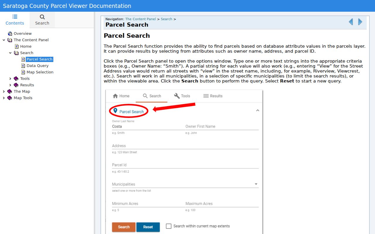
The help screen is useful when a Clifton Park search returns too many parcels, because changing the map extent or municipality can make the street result manageable.
Clifton Park Street Records by Address
Several official sources can be keyed to a Clifton Park address, but they do not carry the same meaning. The property card establishes a parcel and owner of record. The map places that parcel beside others. Recorded instruments explain transfers and legal descriptions. Citizenserve may supply a planning, subdivision, site-plan, lot-line, special-use, or permit trail after an account is created. The portal does not provide a verified public case-search screen, so the Town office or a specific records request is the fallback.
| Clifton Park address record | Keeper | What it can show | Access route |
|---|---|---|---|
| Assessment and property record | Town Assessor / GAR PROS | Owner of record, situs, SBL, sale and building clues | County property portal and assessor |
| Parcel and district map | Saratoga County GIS | Parcels, roads, nearby lots, districts, and map context | Online map viewer |
| Recorded land instrument | Saratoga County Clerk / SearchIQS | Grantor, grantee, deed detail, legal description, maps | Account, public computers, counter, phone, or mail request |
| Town planning or permit material | Clifton Park Citizenserve and Town offices | Application or project context when records exist | Account route, office inquiry, or FOIL request |
| Voter status | NYS Board of Elections | An individual’s eligible status or polling information | Individual lookup, not a street roster |
Clifton Park records requests may proceed under the Saratoga County FOIL process and the New York Freedom of Information Law (FOIL), New York Public Officers Law Article 6, §§84–90. Name the address, record type, date range, and requested format. An agency can withhold or redact exempt material.
Trace Clifton Park Street Deed Chains
After GAR PROS supplies a Clifton Park SBL and deed clue, SearchIQS can connect the address to the recorded instrument. Search the current owner as grantee, select deeds, and use a suitable date range. Record the grantor and grantee names, recording date, book or page or document number, and whether an image is available. The next check is the legal description. It should match the SBL, map or lot reference, and physical parcel before the chain moves back.
Search the seller or grantor as the next earlier grantee. Also consider mortgages, satisfactions, lis pendens, judgments, liens, and maps as dated evidence. A Clifton Park road can cross tax-map sections, school or fire districts, and postal identities. Searching adjacent parcels separately prevents a similar street label from being mistaken for the same lot.
Note: A recorded deed establishes a land transaction, not a claim that every indexed party lived on the Clifton Park property.
Clifton Park Street Deeds Before Modern Search
Land records in Saratoga County reach to 1791, making old index books the key numbers story for a Clifton Park address search. Deeds from December 1987 to the present have modern index data and images in SearchIQS. Deeds from 1791 through November 1987 are represented through scanned index books, data, or images according to the document coverage. A failed modern name result therefore does not end a Clifton Park ownership search.
For older material, browse the index-book images and use the County Clerk’s public computers or counter when the online path is incomplete. The Clerk offers research access in Ballston Spa, as well as phone and mail channels for historical availability and copies. The county lists public records searching without a fee and states that mailed deed-copy requests require payment and a self-addressed stamped envelope.
Keep Clifton Park Street Labels Aligned
Clifton Park is a town with hamlets, subdivisions, rural roads, and overlapping postal labels. A historic record may use Rexford or Vischer Ferry where a later tax roll uses a Clifton Park mailing identity. The reliable bridge is the parcel: compare the road stem, SBL, legal description, mapped lot, and owner name. The county map service also exposes streets and district layers that help place a record in its proper setting.
No official source reviewed documents a townwide Clifton Park renumbering year or a named road-renaming project. Do not invent one from a missing search result. Use the road stem without a suffix, historic county maps, the GIS street layer, and the SBL or legal description instead. The Town’s Citizenserve application route can provide address-linked planning context after account creation, but it is not a verified public case search.
Clifton Park Street Directory Privacy Limits
Clifton Park street records can identify public parcel and recorded-land information, yet they cannot reliably identify every person at an address. Renters, guests, and many household members do not appear in parcel records. Utility and delivery information is private, DMV address information is restricted, and the voter tool does not publish a street-by-street roster. Address Confidentiality Program participants and confidential voters are intentionally protected from public inspection or copying.
Lawful personal use. Use Clifton Park address records for a legitimate personal, property, civic, or family-history purpose. Never use an address trail to stalk, harass, intimidate, or harm another person.
When a needed public record is not online, use the custodian’s counter, phone or mail channel, or a focused FOIL request. For a past household rather than a present parcel question, the Clifton Park city directory collections offer the more appropriate historical shelf.